The Land of the Book of Mormon
"It has been my experience that most members of the Church of Jesus Christ of Latter-day Saints, when confronted with a Book of Mormon geography, worry about the wrong things. Almost invariably the first question that arises is whether the geography fits the archaeology of the proposed area. This should be our second question, the first being whether the geography fits the facts of the Book of Mormon- a question we all can answer without being versed in American archaeology. Only after a given geography reconciles all of the significant geographic details given in the Book of Mormon does the question of archaeological and historical detail merit attention. The Book of Mormon must be the final and most important arbiter in deciding the correctness of a given geography; otherwise, we will be forever hostage to the shifting sands of expert opinion." -John E. Clark(1)
The goal of this site is to show how one model "reconciles all the significant geographic details in the Book of Mormon." A major feature any model must first reconcile is the "narrow neck" or "small neck of land." The narrow neck of land separates the land southward from the land northward. The top of the Delmarva peninsula on the east coast of the U.S. fits this description of a "narrow neck" of land. Above the Delmarva peninsula is a change in geological features called the “fall line zone.” This zone has a large change in elevation in a short distance and separates the coastal plains of Virginia, Delaware and Maryland from the hard bedrock of the Piedmont. This change gives an understanding on how Mormon would view the land “northward” and the land “southward.” These lands are not just separated by a narrow neck of land, but they also have different geological and ecological features. They truly function as two separate lands. It is not enough to point out that there is a “narrow neck” on a map and ignore the experience from the ground.
Here is a map from the USGS website (2) that shows the generalized fall line:
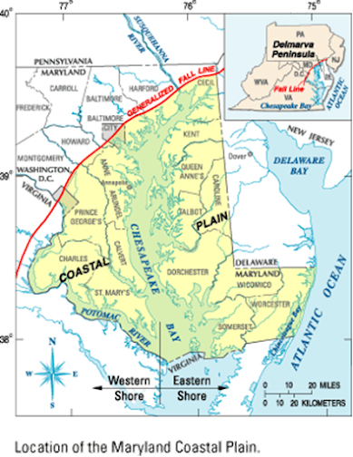
Below the narrow neck of land is the land Bountiful. Above the narrow neck of land is the land Desolation (Alma 22:31). Following the fall line between the land Bountiful and the land Desolation gives a distance of ~40 miles. This is a reasonable distance for a “day and a half journey on the line Bountiful and the land Desolation” (see Alma 22:32). Note that this is not the shortest distance across the peninsula. However, it follows the fall line would be one logical “line” that separates the two lands.
In Helaman 4:7, it reads, “And there they did fortify against the Lamanites, from the west sea, even unto the east; it being a day’s journey for a Nephite, on the line which they had fortified and stationed their armies to defend their north country.” This “one day’s journey” describes a military defense line. It would not need to follow the fall line. As a defensive line, it would most likely be lower in the narrow neck. This line that reaches from the west sea to the east should be around 25 miles.
Just over 250 miles due north from this line, there is a good candidate for what the Jaredites called "Ripliancum." Ripliancum means "to exceed all" (Ether 15:8) and is near hill Ramah (called hill Cumorah by the Nephites). One of the last Jaredite battles took place at the edge of Ripliancum (Ether 15:8). From there, they were pushed toward the hill Ramah, where their final struggle took place. Ramah/Cumorah is located in a "land of many waters, rivers and fountains." The Finger Lakes region fits this description. Even the details of "fountains" can be seen in the 150+ falls in this area (3). The most logical candidate for Ripliancum is Lake Ontario, which, compared to the Finger Lakes truly does "exceed all."


Very interesting, I'm excited to read all these posts. I stumbled on a podcast you were in this morning after beginning to wonder about the Delmarva Peninsula as the Book of Mormon Lands. There are a lot of things that make sense about this model. Thanks for posting this!
ReplyDelete